
How to Save a Place Without an Address and Find It Again Using GPS
A scenic viewpoint, a hidden corner of a village or a place discovered by chance, not every place has an address. Discover how to save a GPS location and find it again whenever you want with GeoFix.
There Are Places That Don't Have an Address
During a trip we often discover places we weren't looking for, a small square, an ancient fountain, a scenic viewpoint or a road leading to an unexpected landscape.
We stop for a few minutes, observe what's around us, perhaps take a photograph and then continue on our way.
Sometimes these are precisely the places that stay with us the most, not necessarily the most famous ones or those featured in travel guides, but those we discovered by chance.
The problem comes when we want to return.
We don't remember the street name, we haven't written down any particular directions and the place might not even appear on maps with a recognizable name, yet we know exactly what we're looking for, that spot where we admired a view, that fountain hidden among the houses or that quiet corner where we stopped during a walk.
To find a place again it's not always necessary to know its address, sometimes it's enough to have saved its geographic location.
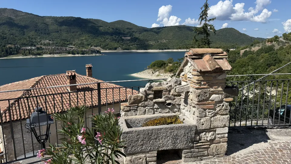
A Fountain Overlooking Lake Turano
Imagine walking through one of the villages overlooking Lake Turano, in Lazio, among narrow streets, stone houses and glimpses of scenery that suddenly open onto the water.
During your walk you come across an ancient fountain, behind it you can see the rooftops of the houses, the lake and the hills surrounding the landscape, you stop to admire the view and take a photograph.
It's not necessarily a place featured in travel guides, it might not have a well-known name and you probably wouldn't know how to explain to someone how to reach it without retracing the streets of the village.
Yet it's a place you'd like to return to, perhaps in another season, when the landscape changes color, or simply to show that view to a friend.
In a situation like this, saving the GPS location allows you to preserve a precise reference to the place, without needing to know the street name or look for an address.
The photograph preserves the memory of what you saw, the geographic coordinates help you know where to return.
Why an Address Isn't Always Enough
We're used to searching for places using an address, a street name, a building number or the name of a business.
This system works well when we need to reach a home, a shop, a hotel or a building identified on maps.
But many places we encounter during a trip don't correspond to a precise address.
A scenic viewpoint might be along a road without a street number, access to a beach might be hidden between two buildings, a trail might begin at an unmarked point and a particularly picturesque corner of a village might not have a name at all.
Even when there's an address nearby, it might identify a building or a street, not necessarily the exact spot we want to remember.
GPS coordinates allow us to overcome this limitation, because they identify a geographic location regardless of whether an address exists.
It's an important difference, especially when we explore lesser-known places or venture away from the most popular routes.
How Saving a GPS Location Works
Every location on the Earth's surface can be identified using two geographic coordinates, latitude and longitude.
Latitude indicates how far north or south a point is from the equator, while longitude indicates how far east or west it is from the Greenwich meridian.
Together, this information makes it possible to locate a place on a map.
Modern smartphones can determine their position using satellite navigation systems, including GPS, together with other information available on the device.
When you save a geographic location, the application stores the coordinates of the point, making it possible to display it again on the map.
This reference is commonly called a waypoint.
A waypoint isn't a route and doesn't necessarily represent a destination that can be reached by road, it's simply a geographic point you've decided to save.
It can correspond to your current position or to a place identified on the map, depending on the features of the application you're using.
If you'd like to learn more about how these geographic references work, we've dedicated an article in our Logbook to what GPS waypoints are and why they can be useful.
How to Save a Place with GeoFix
GeoFix allows you to save geographic locations using waypoints, turning a point on the map into a reference you can consult later.
Imagine standing in front of the fountain overlooking Lake Turano.
You've found an interesting place and want to be sure you can find it again during a future visit.
With GeoFix you can save a waypoint associated with the location, preserving the geographic coordinates of the point you want to remember.
When you return to the area, you can consult the reference on the map and find the saved location again.
The same principle can be used for a viewpoint, a parking area, the entrance to a trail or any other place you want to remember.
You don't need to record an entire route just to remember a location, a waypoint is enough to identify the geographic point.
If you're recording a GPS track during a walk, you can instead use waypoints to highlight particularly interesting places encountered along the way.
In this way, the route tells the story of where you've been, while the waypoints identify the places you want to remember.
How to Find a Saved Location Again
Saving a place is only the first step, the real advantage comes when you want to return.
Imagine visiting Lake Turano again after a few months.
You remember the fountain, the view and the photograph you took, but you don't know exactly which streets you followed to reach it.
By opening GeoFix you can consult the saved waypoint and view its position on the map.
The geographic reference allows you to identify the point you're looking for and compare it with your current position.
This doesn't necessarily mean obtaining an automatically calculated driving or walking route, a waypoint indicates where a place is, while the route needed to reach it depends on the road network, available access points and characteristics of the terrain.
In a historic village, for example, there might be narrow streets, stairways, pedestrian passages or roads that aren't accessible by car.
The waypoint still remains a useful reference, because it allows you to know which location you want to reach, even when you don't know the name of the place.
Not Just Hiking, GPS Can Be Useful in Cities Too
When we talk about GPS, waypoints and geographic coordinates we often think of mountain hikes or outdoor activities.
In reality, saving a location can be just as useful when visiting a city.
Imagine walking through Rome, Florence or Barcelona, during your trip you discover a panoramic terrace, a small hidden garden or a spot where you can photograph a monument from a particular perspective.
These places don't always have easily recognizable names.
You can save their location and return whenever you want, without having to reconstruct the route relying only on your memories.
The same applies to a parking area used during a visit, an entrance that's difficult to notice, a small square discovered by chance or a viewpoint along a river.
GPS isn't just useful for knowing where we are, it can become a tool for building a personal collection of the places we discover.
And this possibility doesn't depend on the type of trip, it can be useful during a vacation, a Sunday walk or simply a day spent exploring your own city.
How Accurate Is a GPS Location?
Geographic coordinates allow us to identify a location, but it's important to remember that the accuracy detected by a smartphone can vary.
The presence of tall buildings, narrow streets, dense vegetation, rock faces or other obstacles can affect satellite signal reception.
In a historic city center, for example, the displayed location might be slightly offset from where you actually are.
For this reason, when saving a particularly important place, it's useful to check that the position shown on the map is consistent with your surroundings.
The moment you record the waypoint can also make a difference, waiting for the device's position to stabilize can help you obtain a more reliable reference.
Another aspect to consider is the accessibility of the place.
Knowing the coordinates of a point doesn't necessarily mean you can reach it directly, there might be private properties, natural obstacles or inaccessible routes.
GPS provides a geographic reference, assessing the route always depends on the actual conditions of the terrain.
A Personal Map of the Places That Matter
Over time, the locations you save can become more than just a collection of coordinates, each point can remind you of an experience.
The fountain discovered during a walk around Lake Turano, a terrace where you watched the sunset, a small beach found during a vacation or an alley where you took a special photograph, these are different places, but they have something in common, they represent moments you've decided to preserve.
Photographs allow you to remember what they looked like, waypoints help you know where they are.
With GeoFix you can add these references to the routes you record, gradually building a personal representation of the places you've visited.
Not just a map of roads, cities and trails, but a map of the places that have held meaning during your travels.
Finding a Place Again Means Being Able to Return
Not all the places we discover during a trip are famous, not all appear in travel guides and not all have an address we can write down.
Sometimes a fountain, an unexpected view or a small corner of a city is enough to make us want to return.
Saving a GPS location means preserving the possibility of finding that place again, even when time has passed and the details of the route have become difficult to remember.
With GeoFix you can use waypoints to save these geographic references, add them to your routes and revisit the places you've discovered.
Because a place doesn't necessarily need an address to deserve to be remembered.
Discover the Places You Want to Remember with GeoFix
Save the locations that matter, record your routes and build your personal map of the places you've explored.
Discover GeoFix at geofixgps.com
GeoFix, wherever you go.