
Augmented Reality and GPS: Discover the Places Around You with GeoFix AR
Do you look at the landscape and wonder what's in front of you? With GeoFix augmented reality you can explore geographic points through your smartphone's camera and discover a new way to see the world around you.
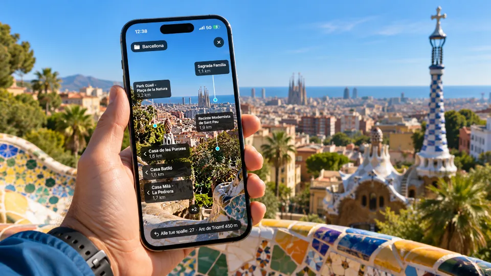
When the Landscape Becomes a Map
You've reached a scenic viewpoint, before you stretches a landscape of hills, trails, small villages and places you don't know, you stop to observe your surroundings, you recognize some landmarks, but others spark your curiosity.
What's the name of that place in the distance? Where is the point you saved during your hike? In which direction is a place you'd like to reach?
Normally you would take out your smartphone, open a map and try to compare what you see on the screen with the real landscape, but what if you could look directly at the surroundings through your camera and see geographic references overlaid on the image?
That's exactly the idea behind augmented reality.
What Is Augmented Reality
Augmented reality, often referred to as AR, is a technology that allows digital information to be added to our view of the real world.
Unlike virtual reality, which recreates an entirely digital environment, augmented reality keeps your surroundings visible and enriches them with additional information.
Through your smartphone's camera you can continue to see the landscape, while references appear on the screen to help you interpret it.
In the context of geographic exploration, these references can be associated with places, coordinates and points of interest.
The map doesn't disappear, but is complemented by a different way of observing the surrounding environment.
GeoFix AR, Where Geographic Points Meet the Real World
With GeoFix AR, augmented reality becomes part of the experience of exploring the world around you.
The feature allows you to observe your surroundings through your smartphone's camera and display geographic references associated with available points.
A waypoint you've saved, a place you want to identify or a geographic reference can therefore be displayed in relation to the direction you're looking, instead of interpreting only symbols on a map, you can connect digital information with what you actually see in front of you.
Imagine being on a seafront promenade and wanting to locate a nearby saved point, or standing at a scenic viewpoint and looking for a geographic reference in the landscape.
GeoFix AR adds another layer of information, turning your smartphone into a tool for visually exploring your surroundings.
From the Map to the Landscape
Traditional maps represent the terrain from above, they are valuable tools for understanding distances, routes and locations, but when we're physically in a place, our perspective is completely different, we don't see the terrain from above, we see roads, buildings, trees, mountains and horizons.
To compare these two perspectives we need to interpret the map and orient ourselves in the real world, augmented reality helps create exactly this connection, viewing a geographic reference through the camera can make it easier to understand the direction in which it's located.
It's a way to move from coordinates to the landscape, maintaining the connection between geographic information and real-world experience.
Not Just Mountains, Augmented Reality in the City Too
When we think about GPS we often imagine trails, hikes and natural environments, but exploration doesn't stop at the edge of a forest, it can begin during a walk through an unfamiliar city, in a seaside village or along a road you're traveling for the first time, augmented reality can be interesting in these settings too.
Imagine walking through Barcelona, standing on the seafront in Marina di San Nicola or visiting an unfamiliar destination, you can observe your surroundings through GeoFix AR and connect the available geographic references with the places around you.
You don't need to be in a remote location to experience the pleasure of discovery, sometimes all it takes is a closer look at a place we see every day.
How Accurate Is GPS Augmented Reality?
To display geographic references in relation to the real world, a smartphone uses information from its positioning systems and device sensors, the accuracy of the display therefore depends on several factors.
GPS signal quality, compass accuracy, magnetic interference and environmental conditions can affect the positioning of elements on the screen. Near buildings, rock faces or other obstacles, the indications may be less accurate, which is why it's important to consider GeoFix AR a tool for exploration and visual orientation, not a guarantee of an object's exact position or whether a particular direction is passable.
A point displayed in front of you might be beyond a building, a natural obstacle or an inaccessible section of terrain, augmented reality indicates a geographic reference, it doesn't replace route assessment.
Another Way to Discover the World Around You
GPS technology has accustomed us to knowing our position through coordinates and maps, augmented reality introduces a different perspective.
It's not just about knowing where we are, but about connecting what we know with what we can see, a place saved during a trip, a waypoint associated with a memory or a geographic reference can become part of how we observe the landscape.
It's a way to bring the digital world closer to the real one, without losing the pleasure of looking around.
GeoFix AR was created with this idea in mind, to accompany exploration and offer a new tool for understanding the world around us, because there are places we look at without truly knowing them and sometimes all it takes is a change of perspective to begin discovering them.
Discover GeoFix AR
Explore your surroundings through augmented reality, save your waypoints, record your routes and discover GeoFix's navigation tools.
Discover GeoFix at geofixgps.com
GeoFix, wherever you go.